Baseline Datasets
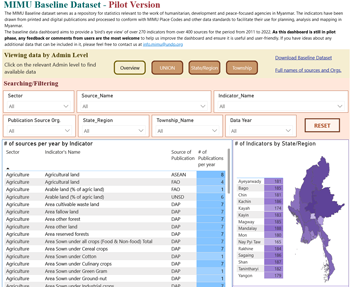
The MIMU Baseline Dataset tracks available data from published sources on more than 270 indicators across 13 sectors to support planning and monitoring processes. The MIMU team gathers data at the lowest administrative level at which it is available (i.e. Union, State/Region or Township level), and digitizes this in the form of an Excel table. Data from some sources, such as the Education and Health Information Management Systems, has been entered for several consecutive years allowing us to use the MIMU Baseline data to track trends at township level. We continue to look for new data sources that could be usefully included in the Baseline Dataset. If you wish to share your organization’s baseline/survey data, need more information on available data, or have suggestions on data that could usefully be included, please contact us at [email protected] To use the MIMU Baseline Dataset: Begin with the MIMU Indicator List to decide which data is most relevant for your needs, then refer to the MIMU Baseline Data file to obtain the actual data/statistics.
MIMU Indicator List & Dashboard
The Indicator List file contains a summary of the available information on over 250 indicators in the MIMU’s baseline database. Data is presented by sector and includes the following information: Definition (from primary source and/or other sources), Category/sector (e.g. Demography); Indicator detail (e.g. Population density); Data Sources (e.g. IHLCA survey); Start/Latest Year; Level of available data – this indicates sources providing data to national, state/region or township level. This file should be used first to determine the general characteristics of data you are seeking, after which you can use the Baseline Dataset file or dashboard to obtain the data itself.
| Title | Format | Size | Uploaded |
|---|---|---|---|
| MIMU_Metatdata_Baseline_Indicators_5Mar2025.xlsx |
xlsx |
193.27 KB | 04-Mar-2025 |
MIMU Baseline Data
The Baseline data files list the available data values from various sources for each indicator tracked by the MIMU. The data in these files is updated on a regular basis as new datasets are received and processed. If you wish to share your organization’s baseline/survey data, need more information on available data, or have suggestions on data that could usefully be included in this data tracking, please contact us at [email protected].
Excel Mapping Tool
This tool uses MIMU Place Codes to enable the preparation of simple "heatmaps" to compare data from Excel spreadsheets across states/regions and townships. It can compare and contrast different indicators from larger, national datasets such as the 2014 Myanmar Population and Housing Census, and also used with agencies' own information from different areas.
| Title | Format | Size | Uploaded |
|---|---|---|---|
| Excel_Heat_Mapping_MIMU_V206_20200513.zip |
zip |
21.21 MB | 14-May-2020 |