Using OpenStreeMap (OSM) for Humanitarian and Development Activities
- by Center for Development and Environment (CDE), University of Bern
What is OpenStreetMap
OpenStreetMap (OSM) is a collaborative, open-source mapping project that provides free, editable geographic data to users worldwide. Created in 2004, it operates like the "Wikipedia of maps," allowing anyone to contribute by adding and editing roads, buildings, landmarks, and other features. The data is primarily created by OSM volunteers through digitizing features based on satellite imagery, using GPS surveys, and incorporating local knowledge. The data can be further enhanced by importing suitable datasets, resulting in a highly detailed and constantly evolving map. Unlike proprietary mapping services, OSM’s data is open and freely available under the Open Database License (ODbL), allowing individuals, businesses, and humanitarian organizations to use, share, and adapt it—provided they attribute OSM and share any derived data under the same license.
OSM has a vast and active global community, including volunteers, GIS professionals, and organizations like the Humanitarian OpenStreetMap Team (HOT), UN Mappers and the Red Cross. The OSM ecosystem (data, applications, community) serves a wide range of applications incl. disaster response, transportation, research, and sustainable development projects.
All data in OpenStreetMap (OSM) are contributed by volunteers who follow OSM guidelines to create a consistent, large-scale (mostly topographic) map of the world. These guidelines aim to ensure detailed and accurate mapping while allowing the flexibility needed to represent diverse geographic features found across the globe. Anyone can edit OSM data using free tools like JOSM and the iD Editor, helping to keep the map up-to-date, add missing details, and correct inaccuracies. This collaborative approach has earned OSM the reputation of being the "Wikipedia of cartography."
Furthermore, with OSM being one of the best available map of the world, it is used by countless applications as a basemap and in analyses, and is easily available to be used in GIS applications such as QGIS and ArcGIS.
Links:
- The OpenStreetMap website www.openstreetmap.org is the main platform for viewing, editing, and accessing OpenStreetMap (OSM) data.
- The OSM wiki https://wiki.openstreetmap.org is the official documentation hub for OpenStreetMap (OSM)
How can I use OpenStreetMap basemaps
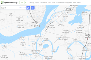
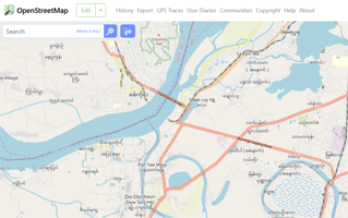
The OSM data, the database which is constantly edited and improved by the OSM community, is used to create interactive maps, similar to google maps.
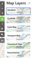
The default map application can be accessed at https://www.openstreetmap.org/ and offers currently 6 styles, each displaying the data in a different way, e.g. with a stronger focus on transport related features, features important for humanitarian needs or trying to provide a more general-purpose layout. In countries that are using a non-roman script, some of those layouts also display the English names of places and features additionally to the names in local script. Though, they all use the same OSM database to create those different layouts.
Many integrate the OSM basemap in their applications, e.g. MIMU uses OSM for their interactive Sagaing Earthquake map, https://themimu.info/webmap-sagaing-earthquake-2025, the Global Disaster Alert and Coordination System https://www.gdacs.org and many more.
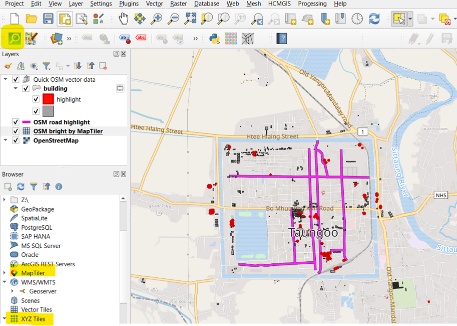
You can also use OSM as a basemap e.g. in QGIS and ArcGIS.
In QGIS either through the XYZ tile layer functionality (https://www.giscourse.com/how-to-add-openstreetmap-basemaps-in-qgis-3-0/) or using a plugin such as QuickMapServices which includes OSM based maps.
Companies like MapTiler, MapBox etc. primarily base their maps on OSM data and some of their maps can be used for free e.g. in QGIS.
OSM can also be used on your phone and works fully offline, meaning once the database for a country is downloaded, you don’t need an internet connection to fully use the map and app. This is especially useful in Myanmar where reliable internet access can be a challenge.
Popular navigation apps for your phone that use the OSM database are Organic maps https://organicmaps.app (which is free) and Maps.me.
OSM data is also used for analysis e.g. the Copernicus Emergency Mapping is using OSM road data for its road damage assessments following the Myanmar 2025 earthquake https://mapping.emergency.copernicus.eu/activations/EMSR798/
Links:
- OpenStreetMap Website https://www.openstreetmap.org/
- Quick Map Services plugin for QGIS https://plugins.qgis.org/plugins/quick_map_services/
- Map tiler plugin for QGIS https://www.maptiler.com/qgis-plugin/
- Renderer of OSM using Local and english script https://thaimap.osm-tools.org/
- Organic Maps - free OSM offline Navigation app https://organicmaps.app
- Maps Me - popular OSM Navigation app https://maps.me/
How can I download data from OpenStreetMap to make my own maps & analysis
If you want to do more with OSM data than using them as a basemap, OSM under its ODbL licence also allows you to download and use all the data. Thus, you can use OSM data to create your very own custom layouts, use it in analysis and integrate it into your GIS projects – making OSM the biggest open map data repository. This is a major difference to Google maps which, as it is a commercial product owned by Google/Alphabet, does not allow this.
You can download OpenStreetMap (OSM) data using different tools and in different formats depending on what fits your needs best.
Websites like Geofabrik and HOT Export Tool (https://export.hotosm.org/v3) let you select specific areas and download map data easily. For more customization options or larger downloads, you can use tools like Overpass Turbo or download the full OSM database. Plugins such as QGIS quickOSM also make downloading vector data from OSM easy.
myOSM, the Myanmar OSM community, also provides consolidated monthly updated downloads of roads, settlement areas and building footprint layers for Myanmar to provide easy access to some essential OSM data to Myanmar users. Those myOSM layers filter and simplify the OSM data and classification a bit to make them easier to use.
Links:
- HOT export tool https://export.hotosm.org
- Geofabrik https://download.geofabrik.de/asia/myanmar.html
- Overpass Turbo for larger script based downloads https://overpass-turbo.eu/
- plugin for QGIS https://plugins.qgis.org/plugins/QuickOSM/
- plugin for QGIS guide https://www.seepuuyar.com/qgis334_training_manual_mm/docs/training_manual/qgis_plugins/plugin_examples.html#quickosm-plugin-follow-along-the-quickosm-plugin
- myOSMexports https://drive.google.com/drive/folders/1v3DMSOJlNz3Ph7lBjLXNZlcBOjMPXLWV?usp=sharing This folder contains OSM dataset extracts in *.shp and *.gdb format, prepared by myOSM and with simplified classification added for easy access and use by those unfamiliar with the other OSM data download tools.)
Limitations and known issues of OpenStreeMap data for Myanmar
As OpenStreetMap is built by a global community of volunteers, which means its data is not officially verified or authoritative like government or some commercial maps. While many contributors strive for accuracy, OSM data can sometimes be incomplete, outdated, or inconsistent, especially in areas with fewer mappers. Since anyone can edit the map, errors or accidental mistakes can occur, and there is no central organization guaranteeing its accuracy.
OSM data quality varies by country, and in places like Myanmar, there are challenges with completeness, accuracy, and consistency. Some areas may have missing roads, outdated place names, or incorrect boundaries due to limited contributors and outdated sources. Data can also be messy, with duplicate entries, inconsistent tagging, and features not following OSM standards. Since OSM relies on volunteers, the level of detail depends on local mapping efforts, making some areas highly detailed while others remain sparse. Users should always check if the OSM data for their area of interest is fit-for-purpose.
Generally, OSM data for Myanmar, compared to many other parts of the world, is of rather poor quality and coverage. Nevertheless, despite its limitations, in countries like Myanmar, OSM is often the only available source of large scale topographic map data, making OSM, despite its limitations, a highly valuable resource used by many.
myOSM and the wider OSM community is striving to improve the data availability and quality, especially for essential layers such as roads, settlements, critical infrastructure, rivers and other essential topographic features as well as building footprints.
Check the “About myOSM” section, to learn for what areas in Myanmar roads, settlements and other essential features have already been improved and checked for completeness and quality to make them a dependable data source for many uses.
How can I help making OpenStreetMap better
Anyone can help improve OpenStreetMap (OSM) by adding or updating map data. You can start by learning from various good resources such as
- https://www.seepuuyar.com/osm-unmaps-guides/
- https://mappers.un.org/learning/
- https://learnosm.org/en/
- https://wiki.openstreetmap.org/wiki/Map_features
By creating a free account on openstreetmap.org and using one of the map editors such as JOSM or iD editor you can add new roads, buildings, or points of interest. You can also improve the map by fixing mistakes, adding street names, or reviewing satellite imagery. Even small contributions, like adding building footprints, adding missing roads, schools and public facilities help make OSM more accurate and useful for everyone.
You can help
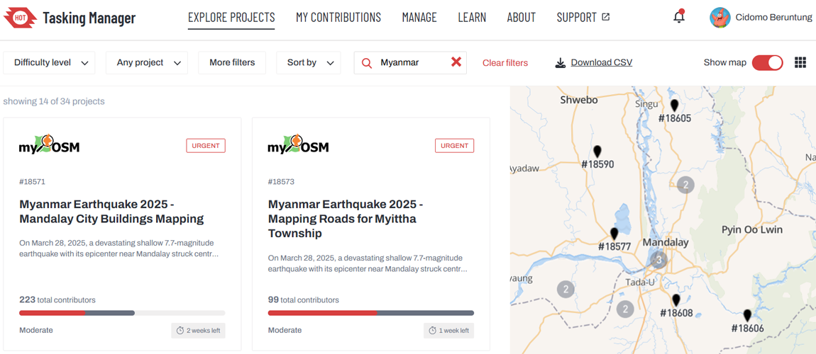
- mapping priority tasks announced through the HOT Task Manager. https://tasks.hotosm.org/explore?omitMapResults=0&text=Myanmar and
- keep informed via the Myanmar OSM facebook page https://www.facebook.com/groups/osmmm
You can join the myOSM community, which regularly organizes trainings, mapping events, and campaigns to improve OpenStreetMap in Myanmar. To encourage and support dedicated volunteers, myOSM offers mini-stipends to some of the most active contributors.
If you'd like to help expand this initiative, you can support myOSM with a small donation ([email protected]). Every contribution goes to 100% toward increasing the number of mini-stipends, enabling more passionate mappers to dedicate time to improving OSM while also enhancing their skills.
About the Myanmar OSM community

Disclaimer: The content on this sub-page has been created and is maintained by CDE Myanmar as part of the myOSM initiative. MIMU is not responsible for the accuracy, completeness, or reliability of the information provided.