Satellite-Based Comprehensive Damage Assessment Report
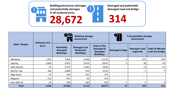
On 28 March 2025, the United Nations Satellite Centre (UNOSAT) Emergency Service was activated in response to the earthquake. UNOSAT used a wide range of pre- and post-event satellite imagery. The analysis primarily focused on providing an overview of the distribution and the extent of the damage caused by the earthquake. In addition to the population exposure analysis, UNOSAT conducted several comprehensive damage assessments over designated areas of interest to estimate the number of affected structures. The damage assessments were based on a series of pre- and post-event satellite images covering the areas of interest.
This comprehensive satellite-derived building damage analysis identified a total of 28,672 buildings or structures with visible damage in the assessed areas, including Magway, Mandalay, Sagaing, Bago (East), Nay Pyi Taw, Shan (North), and Shan (South) States. Additionally, approximately 314 locations with damaged or potentially damaged roads and bridges were identified..
📝More details in the report.
Vulnerable Construction Turned Myanmar Earthquake into Widespread Catastrophe, Finds UNU Analysis
The United Nations University Institute for Water, Environment and Health (UNU-INWEH) recently published a report,calling for enforcing resilient building codes and using remote sensing based rapid response systems for saving lives.
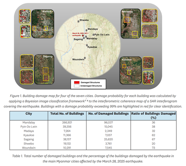
Using synthetic aperture radar (SAR) data from the Sentinel-1 satellite, UNU researchers assessed the damage in the hard-hit cities of Mandalay, Pyin Oo Lwin, Madaya, Kyaukse, Sagaing, Shwebo, and Woundwin. Key findings from the report detail the widespread destruction, with over 157,000 buildings identified as likely damaged.
📝More details in the report.