News

Our map and infographics (Myanmar Language, English Language) of Townships with known landmine contamination and casualties in Myanmar has been updated for 2023/2024. This was created in collaboration with the International Campaign to Ban Landmines (ICBL). As shown on the map, from 1999 to 2024, the cumulative suspected Landmine/ERW contamination has been reported in 190 (58%) of Myanmar's townships. In 2023 alone, Landmine/ERW casualties were recorded in 134 of those townships.

Infographic on the medical treatment of civilian mine victims were also released earlier.

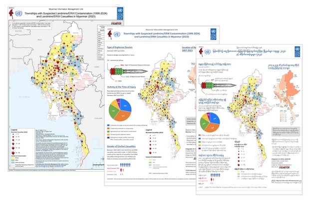
Landmine injuries, and injuries from other found explosive remnants of war (ERW), place an enormous burden on public health and social services.

When compared to other injuries, landmine casualties usually require multiple surgeries and larger quantities of blood transfusions.

Recovery from a landmine injury is not swift and usually requires long hospital stays.

Limb loss is not uncommon and in those injuries, once they are in recovery, the amputee will need to be provided with a prosthetic limb. These require maintenance over the rest of the mine victims’ lifetime.

Even with an artificial limb, they may not be able to return to their former occupation. This requires vocational assistance. The mine victim may also need to access psycho-social counseling to cope with the potential mental trauma.

In its current state, Myanmar’s public health system can rarely provide all the above, especially the immediate life saving medical care following such injuries. The associated costs can devastate rural families, pushing entire households into poverty.

In order to highlight these issues, in collaboration with the Landmine Monitor, we have made an infographic which is now available to download through the dedicated Mine Action page.

Earlier this week, we have developed probable flooded area maps from October 3 and October 5, caused by heavy rains following Typhoon Krathon. These cover parts of Bago, Mandalay Regions, Shan and Kayah States.

These are now available on our dedicated page on 2024 Monsoon Flooding.

The latest MIMU village-level township maps, updated in accordance with Pcode version 9.5, are now available on the GIS resources page of the MIMU website.

The updated overview dashboard shows 2,570 assessments contributed by 197 agencies across 25 sectors of humanitarian and development activities as of July 2024. 42% of the reported assessments/publications have been done at the countrywide level, followed by Rakhine (13%), Shan (North), Yangon, Ayeyarwady, Mandalay and Kachin.

Please find more detailed information of assessments/publications through the link HERE.
Agencies' continued participation is very much appreciated.

Please contact [email protected] for any further query, and be sure to share information on planned, ongoing or completed assessment/publications.

The latest map from MIMU explores seismic activity in Myanmar and nearby regions over the last 100 years. More resources can also be found in MIMU’s dedicates page for earthquake emergency preparedness and response.

New versions of MIMU Administrative Maps, Physical Maps and States/Regions and Townships Map are now available with the updated information.

"MIMU Community", the very first Viber channel from MIMU, was launched today. This Myanmar-language channel will offer regular updates to support the humanitarian, development, and civil society actors in Myanmar. It will feature Myanmar-related data, maps, publications, resources, and job vacancies from partner organizations, along with MIMU-developed products.

Myanmar is a country known for its ethnic diversity with around a hundred languages as illustrated in MIMU's 'Main Spoken Languages of Myanmar' map. Recognising this diversity is crucial for effective engagement with beneficiaries in humanitarian and development activities.

Over the years, MIMU has collected many awareness, information, education, and communication (IEC) materials in ethnic languages covering themes such as health, maternal and child care, COVID-19 response, disaster, and cyclone preparedness/response. These materials, sourced from and contributed by various organisations, include posters, infographics, manuals, as well as audio/video files.

As of August 2023, our repository includes over 250 different resources in 24 ethnic languages. This page aims to provide a single, easily accessible location for these while inspiring to create more inclusive resources targeted at ethnic communities.

MIMU's Infographics on Gender Equality in Myanmar in both Myanmar Language and English Language have been updated with data from 2014 to 2021, with support from UNFPA Myanmar. It is now also available as an interactive dashboard.

Myanmar’s 2021 state of gender equality in reproductive health, empowerment, and the labor market was summarised with developments (or lack thereof) since 2014.