In yesterday’s updates, we highlighted the earthquake damage to hundreds of religious buildings, heritage and cultural sites, with the earthquake’s epicenter near historic cities Sagaing and Mandalay.
Since then, the United Nations Satellite Centre (UNOSAT) has released 4 more maps to assess probable damage at many of those sites in Myanmar using very high resolution satellite imagery.
The summary below combines those from yesterday with today’s four new maps:
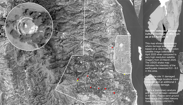
- Min Kun – 11 damaged / 3 possibly damaged
- Pinya – 6 damaged / 5 possibly damaged
- Mahamuni Pagoda – 30 damaged within the area
- Tada-U – 34 damaged buildings within the cultural site were observed and an additional 7 buildings have possible damage
- Innwa (Ancient Cities of Upper Myanmar) – 18 damaged / 2 possibly damaged buildings inside the site, 25 damaged / 5 possibly damaged in its buffer zone, plus damaged southern wall.
- Mandalay Palace & city walls – 17 damaged / 9 possibly damaged structures and multiple damages in the moat wall.
- Amarapura – 8 damaged within the cultural site including two towers (inset 1), the Shwe Lin Pin Pagoda (inset 2) and another pagoda on the south-eastern wall.
- Sagaing – 760 damaged buildings within the cultural site, including several pagodas such as Ma Shi Khana Pagoda. No damage detected on the Sitagu International Buddhist Academy.
- Mingun – 4 damaged buildings within the cultural site, including the Hsinbyume Pagoda, Mingun Pahtodawgyi and Sat Taw Yar Pagoda.
- Bagan World Heritage Site (Component 7) – no visible damage
- Shwe Kyaung Monastery (Konbaung period wooden monastery) – no visible damage
- Sri Ksetra (Pyu Ancient Cities) – no visible damage
Please Note: This is a preliminary analysis based on satellite imagery and has not yet been validated in the field. UNOSAT welcomes ground feedback to refine the assessment.
Download the maps on MIMU website.