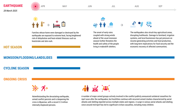
Two months since the earthquake
People of Myanmar face escalating crisis amid earthquake devastation and protracted conflict.
The combined impacts of the recent earthquakes and ongoing challenges have deepened humanitarian needs across Myanmar, leaving millions in heightened vulnerability. A multisector initial rapid assessment conducted by the UN and its partners identified priority needs, including cash, food, construction materials and emergency shelter support across 44 earthquake-affected townships in Bago, Kayin, Mandalay, Nay Pyi Taw, Sagaing and Shan.
More than 75 per cent of the assessed localities have received assistance since the earthquakes, though continued support remains essential to address urgent needs.
📝Read more in the Myanmar Humanitarian Update No. 46 from UNOCHA.
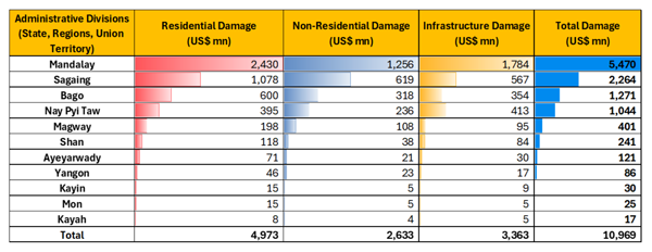
GRADE Report
The Global Rapid Post-Disaster Damage Estimation (GRADE) report summarizes the direct economic damage to buildings and infrastructure caused by the March 28, 2025, magnitude 7.7 earthquake in Myanmar. It provides critical insights to support response, recovery planning, and strategic discussions on risk reduction.
- Total direct economic damage is estimated at US$10.97 billion, equivalent to about 14 percent of Myanmar’s GDP for financial year (FY) 2024/25.
- Residential buildings suffered the highest damage, accounting for US$4.97 billion (45 percent of total damage).
- Affected households in the most impacted administrative divisions could experience consumption losses of up to 25 percent.
- Recovery and reconstruction costs are expected to significantly exceed direct damage estimates.
📝Read more in the report.
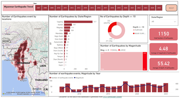
Power BI for Disaster Preparedness and Response
Earthquake response and data were key parts of the recently completed Power BI Training from MIMU. Here is an example of a great final project from training participants. Data analysis tools such as Power BI and Tableau play a key role in information management processes during disasters.
Please keep an eye on this newsletter for announcements about the next training.
Meanwhile, you may also learn Power BI through our online resources.
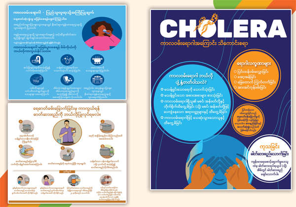
Health Resources for Monsoon Season
Information, Education, and Communication (IEC) materials for monsoon season, including posters on cholera and influenza, are now available on the MIMU website.
📝 Explore on MIMU’s Emergency Resources page.
Environmental considerations in shelter projects
The Myanmar Environmental Country Profile (ECP) offers practical guidance for Shelter/NFI/CCCM Cluster partners in Myanmar, focusing on integrating environmental sustainability into shelter and settlement interventions.
📝 Read more in the guidance note.