
News

MIMU has been providing dedicated webpage service for clusters and areas of responsibility (AoRs) to share their key resources.

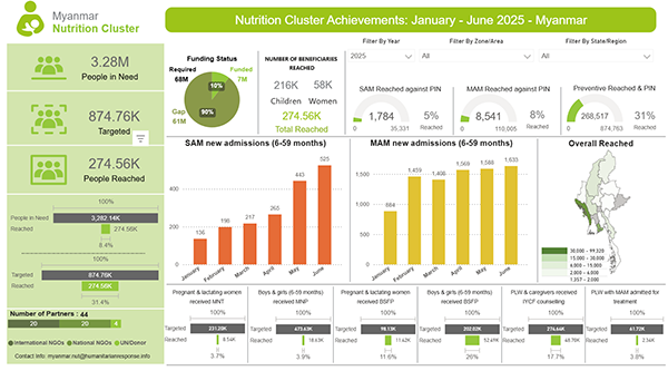
This week, the Nutrition Cluster and Child Protection AoR released updated progress dashboards that track achievements against the indicators in the Myanmar Humanitarian Needs and Response Plan (HNRP) 2025.

Despite significant funding challenges, only about 10 percent of the Nutrition Cluster’s required budget has been covered so far, these groups have been working hard, with the Nutrition Cluster already reaching 31 percent of its targeted population.

📝Explore the Nutrition Cluster Dashboard.
📝Explore the Child Protection AoR Dashboard.
The humanitarian community in Myanmar has established the ERP WG in an effort to reinforce its readiness to respond flexibly to a range of potential hazards despite these new uncertainties.

The ERP WG provides a platform for stakeholders (including CSOs, international and national NGOs, the International Red Cross and Red Crescent Movement and UN agencies,) to jointly prepare for effective and efficient humanitarian responses to potential future hazards affecting Myanmar, mitigate the impact of disasters and save as many lives as possible from preventable causes.

To that end, this dedicated page on the MIMU website will serve as the central hub to support the Working Group’s coordination, planning, information sharing, and advocacy at both national and local levels.

📝Explore the page.

Effective monitoring of water levels, whether for rivers or man-made water retention structures like dams, is important for flood preparedness and response, particularly during Myanmar’s monsoon season. The newly launched Dam Water Level Dashboard by Myanmar Geoinformatics Society complements the River Water Level Dashboard and provides an interactive way to monitor the current status and short-term trends of water levels across dams countrywide.

📝 Explore the dashboard hosted on MIMU website.

Based on satellite imagery as of 30 July 2025, MIMU has just developed a number of probable flooded area maps to support emergency response. More maps will be released as data becomes available.

These are now available on the newly created page on MIMU website for flood emergency resources.

The map released this week covers:

  • Bilin, Thaton (Mon State) and Hlaingbwe, Hpa-An and Kyaikmaraw Township (Kayin State)
  • Kyaukkyi, Shwegyin, Nyaunglebin, Daik-U and Waw Township (Bago Region)
  • Taungoo, Oktwin, Htantabin, Phyu and Kyaukkyi Township (Bago Region)

Understanding rainfall patterns can help mitigate and prevent the flood risks given Myanmar’s vulnerability especially during the Monsoon Season. 

Newly released dashboard from MIMU let you explore interactive rainfall data to better understand historical trends, regional variability, and predictive insights for effective planning and decision-making.

📝 Explore the dashboard.

Based on satellite imagery as of 23 July 2025, MIMU has just developed a probable flooded area map to support emergency response. More maps will be released as data becomes available.

These are now available on the newly created page on MIMU website for flood emergency resources.

The map released this week covers:

  • Lemyethna, Yegyi, Thabaung, Kyaunggon and Kangyidaunt (Ayeyarwady Region)

Market Price Report (MPR) provides data from 40 townships across 8 states/regions in Myanmar. Data are collected from three vendors per product per market at the end of each month.

Rapid Market Assessment (RMA) provides data on market function, supply, activity, and logistics in 56 non/earthquake townships across 9 states/regions. Data were collected primarily June 20-26 through observation and KIIs with 108 retailers.

Based on satellite imagery as of 13 July 2025, MIMU has just developed a number of probable flooded area maps to support emergency response. More maps will be released as data becomes available.
These are now available on Emergency Resources page on MIMU website.

The maps released this week cover:

  • Monyo, Minhla, Letpadan and Thayarwady (Bago Region) and Ingapu, Hinthada and Zalun Township (Ayeyarwady Region)
  • Nyaunglebin, Daik-U, Waw and Thanatpin Township (Bago Region)
  • Salin, Chauk, Pwintbyu, Yenangyaung, Minbu and Magway Township (Magway Region)
  • Yesagyo and Pakokku Township (Magway Region) and Myingyan, Taungtha and Nyaung-U Township (Mandalay Region) 

In a new paper titled “The 28 March 2025 Mw 7.8 Myanmar Earthquake: Preliminary Analysis of an ∼480 km Long Intermittent Supershear Rupture”, scientists from Southern University of Science and Technology - SUSTech, UC Santa Cruz and Caltech share new details about the devastating earthquake, which caused widespread and severe damage in Myanmar and neighboring countries such as Thailand. The earthquake ruptured about 480 kilometers of the Sagaing Fault that extends north-south through the central part of the country.

📝 Explore the paper and accompanying press release.

The Inle Lake region has been significantly affected by two major natural disasters in rapid succession. In September 2024, severe flooding caused by intensified Typhoon Yagi inundated large swathes of land surrounding the lake, damaging homes, farmlands, and critical infrastructure. Just six months later, on March 28, 2025, a 7.7 magnitude earthquake struck the Mandalay Region, causing widespread structural impacts and compounding the vulnerabilities of already strained communities in and around Inle Lake.

A new report titled, "Inle Lake Post-Disaster Environmental Assessment and Rehabilitation Plan", was developed by E Guard Environmental Services Co., Ltd. (E Guard) and offers a comprehensive evaluation of the damages sustained, the vulnerabilities exposed, and the opportunities for targeted recovery and sustainable development. It presents detailed findings on environmental degradation, infrastructure damage, displacement, public health risks, and disruptions to water and sanitation systems.

Explore the report in English and Myanmar languages.