One hundred days on, communities continue to grapple with severe challenges across affected areas. Explore the key facts, figures, and priority needs from the ongoing response. Out of the 6.3 million people identified as having urgent needs following the earthquake, 1.8 million of the most vulnerable have been prioritized for humanitarian assistance.
📝 Read more in the infographic from OCHA.
News
- Myanmar's children still grappling with impact of devastating 7.7 magnitude earthquake (UNICEF)
- Lives Rebuilt: Personal Stories from Myanmar’s Earthquake Recovery (WHO)
- 100 Days After the Myanmar Earthquake: Stories from the Margins (UN-Habitat)
- Bamboo and drug prevention: UNODC supports Myanmar’s earthquake recovery
- We Had Everything Then Nothing: 100 Days After the Earthquake, the Wait for Home Continues (IOM)
- In the wake of Myanmar earthquake, a mother finds strength in helping others (IFRC)
- At a small school in Myanmar’s Sagaing region, people find safe haven after a devastating earthquake (IFRC)
MIMU Assessment and Publication Tracking Dashboard has been updated with 29 reports from 14 organisations based on info as of 10 June 2025. Get the overview of ongoing and recently completed works including post-earthquake assessments.
We sincerely appreciate the continued support of all contributing agencies in keeping this important resource up to date.
In April and May 2025, OCHA conducted an access severity monitoring exercise, which included focus group discussions with UN agencies and international and national non-governmental organizations (NGOs) to assess humanitarian actors' perceptions of access difficulties and constraints in all 330 townships covered by the Myanmar Humanitarian Needs and Response Plan (HNRP) and the earthquake response Flash Addendum.
Findings as of 14 May 2025:
- Accessible (Access Severity 1) - 97 townships (about 29%)
- Moderate constraints (Severity 2) - 119 townships (36%)
- Highest access severity (Severity 3) - 114 townships (35%)
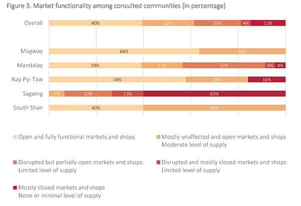
The Food and Agriculture Organization of the United Nations (FAO) and the World Food Programme (WFP) conducted a joint rapid needs assessment in 23 townships across five regions, building on initial impact analyses released immediately after the earthquake.
Market access and functionality have been severely affected, especially in Sagaing and Mandalay, due to the destruction of key infrastructure such as bridges and broader supply chain disruptions. Although basic supplies remain available, soaring transport costs and partial market closures have driven up the prices of food and non-food items, including construction material, and created local shortages.
Crop losses between 20 and 60 percent were reported in key areas such as Sagaing and Amarapura (Mandalay), caused by field cracking, aquifer shifts resulting in drought and localized flooding.
📝 Explore the report for more.
For this round, 14 organizations have provided 29 new Assessments/Publications as of 10 June 2025, bringing the total to 2,633 records from 205 organizations. These are available through the MIMU Assessments & Publications Tracking Webpage. The updated MIMU Assessment Tracking Overview Dashboard will be released in coming weeks.
Thanks to all agencies for your active participation in this exercise.
You are more than welcome to provide updated info of your planned and ongoing assessment at any time online through the submission page (You will need an account and if do not have one, please contact us). Please consult the guideline if you need any assistance or feel free to reach out to us.
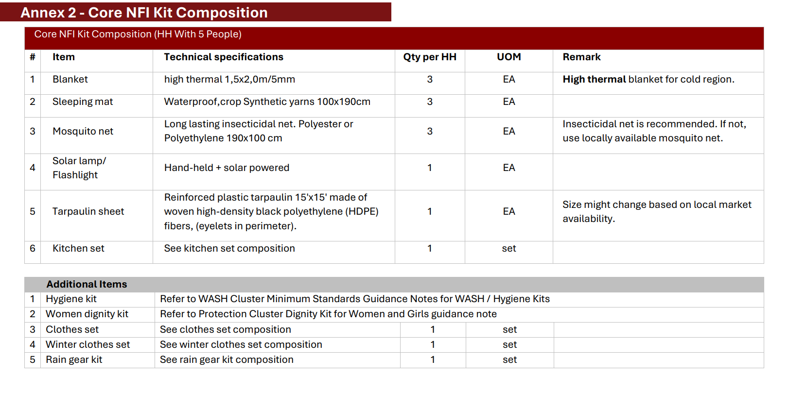
You might have seen the Standard Operating Procedures (SOPs) Cash-Based Interventions for Shelter and NFI that we promoted through this newsletter back in April.
A new document has been developed as a contextualized guidance to the earthquake response annex of the above SOP. For any detailed information not covered in this annex, reference should be made to the above.
The objective is to guide cluster partners on the use of cash as a modality for shelter and NFI assistance to provide dignified and safer living conditions for earthquake affected people, prioritizing the most-at risk families including internal displaced persons, returnees, resettled, locally integrated, non-displaced persons and hosting families. This guidance covers the following type of assistance: NFI, emergency shelter, repair and rehabilitation, transitional shelter, rental assistance and debris removal..
📝Explore the document.
🌐Explore the Shelter/NFI/CCCM Cluster web page on MIMU.
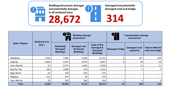
On 28 March 2025, the United Nations Satellite Centre (UNOSAT) Emergency Service was activated in response to the earthquake. UNOSAT used a wide range of pre- and post-event satellite imagery. The analysis primarily focused on providing an overview of the distribution and the extent of the damage caused by the earthquake. In addition to the population exposure analysis, UNOSAT conducted several comprehensive damage assessments over designated areas of interest to estimate the number of affected structures. The damage assessments were based on a series of pre- and post-event satellite images covering the areas of interest.
This comprehensive satellite-derived building damage analysis identified a total of 28,672 buildings or structures with visible damage in the assessed areas, including Magway, Mandalay, Sagaing, Bago (East), Nay Pyi Taw, Shan (North), and Shan (South) States. Additionally, approximately 314 locations with damaged or potentially damaged roads and bridges were identified..
📝More details in the report.
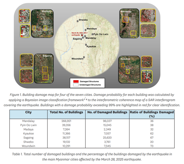
The United Nations University Institute for Water, Environment and Health (UNU-INWEH) recently published a report,calling for enforcing resilient building codes and using remote sensing based rapid response systems for saving lives.
Using synthetic aperture radar (SAR) data from the Sentinel-1 satellite, UNU researchers assessed the damage in the hard-hit cities of Mandalay, Pyin Oo Lwin, Madaya, Kyaukse, Sagaing, Shwebo, and Woundwin. Key findings from the report detail the widespread destruction, with over 157,000 buildings identified as likely damaged.
📝More details in the report.
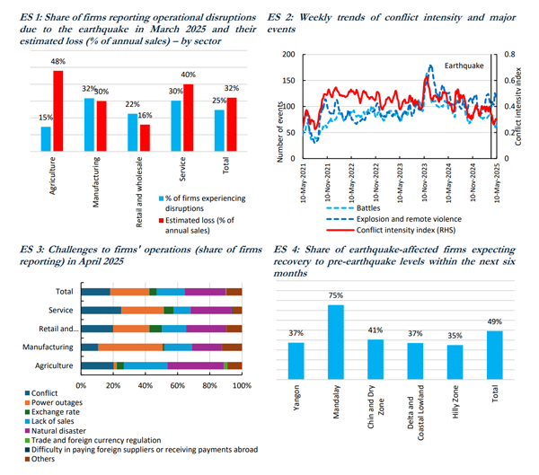
The Myanmar Economic Monitor (MEM), published semiannually by the World Bank’s Myanmar office, has recently released its latest edition. This report covers the impact of the March earthquake, highlighting how the resulting economic aftershocks are compounding ongoing challenges for firms and households.
The MEM projects a 2.5 percent contraction in Myanmar's gross domestic product (GDP) for the 2025/26 fiscal year, primarily due to the earthquake's impact.
Production across all sectors has been disrupted by factory closures, supply chain constraints, labor shortages, and damage to infrastructure. Economic output for the current fiscal year is projected to be approximately US$2 billion lower due to the earthquake. The worst-affected regions, Mandalay and Nay Pyi Taw, are expected to experience about a third reduction in their output between April and September. However, a partial recovery is anticipated in the latter half of the fiscal year, supported by reconstruction efforts.
📝More details in the document.
- ‹ previous
- 9 of 22
- next ›