News

Today marks one month since the devastating earthquake struck Myanmar on 28 March 2025. Affected communities still face severe challenges and urgently need essential supplies and services, while sustainable early-recovery support is critical to help them rebuild their lives and livelihoods.

Drawing on the latest reports from multiple agencies—while data collection and validation are still ongoing—below is a snapshot of the impact and response one month after the earthquake.

Sources: UNOCHA, UNDP, UNFPA, UNHCR, UNICEF, AHA Centre

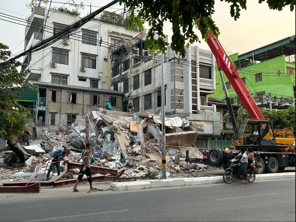
Photo : UNDP Myanmar


Human Impact

  • 3,757 deaths, 5,107 injured, 116 missing (as of 22 Apr 2025, 18:00 MMT) – AHA Centre
  • Over 9 million people (including 2.7 million children) living in the 58 worst-affected townships – UNICEF
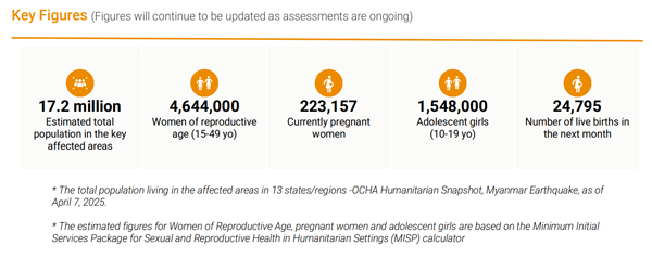
  • 17.2 million people in key affected areas, including 4.6 million women of reproductive age and 223,157 currently pregnant womenUNFPA
  • 2.1 million conflict-affected IDPs also impacted by the earthquake – UNHCR
  • 206,977 people currently displaced; 41,733 of them sheltering in 135 temporary sites – AHA Centre


Infrastructure Damage

  • 55,587 houses damaged (12,441 totally; 43,146 partially)
  • 38 railways, 95 bridges, 407 roads, and 198 locations / 81 bridges along the Yangon-Mandalay Expressway damaged
  • 5,452 office buildings, 2,565 schools, 5,319 religious buildings, 5,342 pagodas, and 304 hospitals/clinics affected – AHA Centre
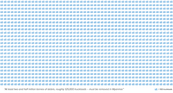
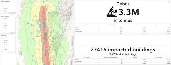
  • 3.3 million tonnes of debris to be cleared – UNDP
  • 640+ health facilities damaged – UNFPA


Highlighted Needs and Responses

  • UNDP: Cash-for-work programmes for debris removal and infrastructure rehabilitation, generating immediate incomes for over 250,000 people. Temporary shelters provided, homes assessed and—where possible—repaired ahead of the rainy season, reaching nearly 50,000 households. Household Emergency Assistance Packages (HEAP) reached 500,000 people in urban and rural areas.
  • Food Security Cluster: Over 413,000 people reached with food assistance in Mandalay, Nay Pyi Taw, Sagaing, and southern Shan.
  • Health: 36 partners delivering essential services across 22 affected townships; 7,300+ people treated at mobile clinics.
    • UNFPA: 18,367 People reached with essential SRH services,including life-saving maternal care and clean delivery kits, in severely affected regions of Mandalay and Sagaing
  • Logistics: Storage capacity remains a critical need, particularly in Mandalay and Yangon.
  • Nutrition: Nearly 500 children and 20 pregnant/lactating women screened for acute malnutrition.
  • Protection:
    • Needs assessments and monitoring covered ~80,000 people.
    • 70,000+ people joined community-based awareness sessions on protection and human-rights risks.
    • MHPSS support reached 325 people in Mandalay, Nay Pyi Taw, Sagaing, and Yangon.
  • Child Protection & GBV:
    • 17,159 people (incl. 14,146 children and 7 persons with disabilities) reached with child-protection services.
    • UNFPA and around 49 partners are delivering MHPSS, legal aid, health services, counselling and referral services, dignity and essential item kits.
    • UNFPA: 18,259 People reached with integrated GBV/MHPSS support, including capacity building and provision of dignity kits and Women Essential Items kits
    • 3,000+ women and girls accessed GBV services; 10,000+ people attended GBV/MHPSS awareness sessions.
    • 7,036 dignity kits and 5,200 women’s essential-item kits distributed.
  • Shelter/NFI: Since the earthquakes, 116,800 people received emergency NFI assistance in 26 townships, and 13,400 received emergency-shelter support in 15 townships.
  • WASH: Many communities still rely on unsafe water sources due to damaged boreholes, broken pipe systems, or contaminated wells. Cluster partners have:
    • Reached 600,000+ people with water-purification tablets.
    • Provided ~241,000 people with water distribution, sanitation facilities, hygiene kits, and hygiene-promotion activities.
    • UNDP supplied clean drinking water to 500,000 people through purification kits, water kiosks, and well-cleaning—ensuring access for persons with disabilities.

To support coordination of humanitarian, development, and peace (HDP)-focused activities across Myanmar, including ongoing response and recovery efforts, products from the latest round of MIMU HDP Nexus 5W (data recorded as of 28th February) have now been released.

198 agencies voluntarily contributed details on their activities via their designated agency focal points. Note that inputs are self-reported and not verified on the ground by MIMU. Reporting agencies include UN agencies, many INGOs, Red Cross and a growing number of local NGOs, with activities categorised into 22 sectors and 152 sub-sectors. Data is collected down to camp/village level, with most agencies reporting at least to village tract level.
 
Data Protection Measures:

  • Agencies can restrict data sharing for specific sensitive projects or areas; agency names will not appear in any HDP Nexus 5W products.
  • Dataset and agency names are no longer shared publicly.
  • Detailed Village Tract level maps no longer public

Available Resources (Explore on the MIMU website):

Interactive Dashboards: Explore data by area or sector without identifying agency names.

Maps: Township-level maps are publicly available (detailed village tract level maps available on request to contributing agencies).

HDP Nexus 5W Data Files with additional details are no longer publicly available but can be provided on request to participating agencies for inter-agency coordination purposes.

The Copernicus Emergency Management Service (CEMS) is one of six services provided by Copernicus, the Earth Observation component of the European Union’s space programme. The Rapid Mapping Service was activated approximately 3 hours after the earthquake and concluded yesterday after analysing 57 Areas of Interest (AOIs) and releasing 68 satellite images.

Based on this data, CEMS estimates that 17,843 buildings and 11.7 km of roads have been affected across these AOIs. Additionally, in AOI28 (Sinthay River), flooding due to a dam breach impacted a built-up area of 1.30 hectares, and 1.50 km of roads.

Review the situation report on the CEMS Activation page.

Download the maps for each AOI here.


The United Nations Satellite Centre (UNOSAT) has been assessing heritage and cultural sites through remote sensing analysis, given the location of epicentre near the historic cities Sagaing and Mandalay. 5 latest maps cover probable damage at the following sites:

  • Pyu Ancient Cities: Halin – No visible damage
  • Pyu Ancient Cities: Beikthano – No visible damage
  • Bagan: Component 6 – No visible damage
  • Mon Cities: Bago, Hanthawaddy – No visible damage
  • Paleik – 26 damaged cultural heritage locations / 14 possible damage

Please Note: This is a preliminary analysis based on satellite imagery and has not yet been validated in the field. UNOSAT welcomes ground feedback to refine the assessment.

Download the maps on MIMU website.

This WFP analysis reviews previous food security and vulnerability data, overlaid with earthquake impact, to refine the design of the food security response. It answers key questions such as where, how many, and who are food insecure.
Where:

  • Regions with largest pre-earthquake food-insecure populations: Mandalay, East Bago, Sagaing.
  • Most affected townships: Sagaing and Shwebo (Sagaing region); Chanmyathazi, Aungmyaythazan, Amarapura, Yamethin, Pyawbwe (Mandalay); Taungoo and Yedashe (Bago).

How many:

  • 2.8 million food-insecure people (2024 data) live in earthquake-affected townships.

Who:

  • Higher rates of food insecurity among displaced populations, rural households, large households, and female-headed households.

Read more and download the report from MIMU website.

Why debris matters – At least two and a half million tonnes of debris, roughly 125,000 truckloads, must be removed in Myanmar. These figures, coming from UNDP’s remote sensing analysis, underscore the urgent need for large scale debris removal and repairs and reconstruction of critical infrastructure and homes as part of the ongoing recovery efforts.

UNDP’s analysis integrated advanced satellite derived building damage classifications from UNOSAT and Copernicus with Microsoft’s building footprint data, supported by local data such as admin boundaries and population figures. This enables immediate targeting of priority areas for debris removal and recycling, guiding the deployment of national engineers to undertake rapid structural assessments of public service buildings, critical infrastructure, and affected homes—information that directly informs rehabilitation and reconstruction plans.

Read more to see how remote sensing analysis shows massive, immediate reconstruction is vital in Myanmar.

Explore the detailed analysis through ArcGIS Story Map.


In the aftermath of a major disaster like the recent earthquake, an early recovery approach takes place during a transition period that represents a vital bridge between emergency relief and longer term development and is crucial to the first efforts of the community to recover and build their resilience.

As one of the few partners with extensive field presences and area based programmes, UNDP is well positioned to gather data and provide immediate quick impact localized responses. UNDP’s vast network of civil society partners enable extended reach into remote more rural areas that are also affected. Furthermore, UNDP can coordinate closely with humanitarian actors, including sharing vital data and teaming with on ground presence.

UNDP’s early recovery priorities include:

  • Restarting micro and small enterprises
  • Repairing vital public infrastructure
  • Debris and waste management
  • Technical and Vocational Education and Training (TVET)
  • Renewable Energy Solutions
  • Rapid socio economic analysis and assessments

Read more on UNDP’s immediate response and early recovery priorities in this document.

Three weeks after the earthquakes, frequent strong aftershocks continue to shake central Myanmar almost daily, increasing fear and uncertainty among affected families, disrupting response efforts, and further exacerbating pressure on already limited resources and services.

Life saving assistance is being delivered on the ground while technical level assessments are under way to guide a more targeted response. Despite these efforts, the scale and urgency of the emergency exceed current response capacity, with needs rapidly outpacing available resources.

See the full breakdown of impact, affected population + response and planned activities in the latest Situation Report from UNOCHA.

  • Education – In 38 townships across eight regions, at least 103,980 school aged children were affected. Assessments in 43 townships found 818 schools damaged and 279 either destroyed or non functional.
  • Food Security – More than 301,000 people need food assistance in 14 townships of Mandalay Region and four townships of Sagaing Region.
  • Health – 640 health facilities were damaged, particularly in Sagaing Region.
  • Logistics – Additional storage space is required in Mandalay and Sagaing to meet rising demand as more relief cargo arrives. 
  • Nutrition – Immediate interventions are essential to prevent deterioration, including emergency life saving services, feeding programmes, multiple micronutrient supplementation, and support for infant and young child feeding (IYCF).
  • Protection – Overcrowded, inadequate living conditions, coupled with rising anxiety and livelihood loss, heighten risks of exploitation, abuse, and other harmful practices—especially for children, women, older persons, and persons with disabilities.
  • Shelter, NFI, CCCM – People in need of shelter, NFIs, and CCCM support have surged from 1 million to 5.2 million in the affected areas.
  • WASH – Rapid needs assessment findings show extensive damage: over 64,000 latrines destroyed and 37 percent of water facilities damaged. In Sagaing Region, only 27 percent of respondents report access to sufficient latrines and 17 percent have access to safe drinking water, well below WASH Cluster emergency response standards.

In the aftermath of the earthquake, negative coping mechanisms—such as early marriage, child labor, and trafficking—are on the rise, necessitating an immediate scale up of gender responsive protection interventions. Overcrowded shelters with inadequate sanitation and hygiene facilities, and a lack of gender segregated shelters or safe spaces, have significantly increased the risks of gender based violence. Psychosocial distress is widespread and continues to worsen due to the more than 200 aftershocks recorded to date, which have disrupted rescue and relief operations. Frontline responders also face emotional exhaustion and secondary trauma.

Learn more about the response from UNFPA and partners including life saving SRH services, gender based violence prevention, and mental health and psychosocial support, in the latest report.

The Market Analysis Unit has just published detailed results from the Rapid Market Assessment (RMA) conducted after the 28 March earthquake in Myanmar. The report provides township level data on market function, activity, supply, and logistics across three earthquake affected regions. Data were collected through observation and key informant interviews with retailers in 25 markets between 1 and 10 April.
Read more on the report.

The Market Analysis Unit is an independent project that provides donors, humanitarian responders, development practitioners and private sector actors in Myanmar with data and analysis to better understand the impacts of market developments, conflict and other crises on household purchasing power, supply chains, financial services, and labour markets.