News

On 28 March 2025, the United Nations Satellite Centre (UNOSAT) Emergency Service was activated in response to the earthquake. UNOSAT used a wide range of pre- and post-event satellite imagery. The analysis primarily focused on providing an overview of the distribution and the extent of the damage caused by the earthquake. In addition to the population exposure analysis, UNOSAT conducted several comprehensive damage assessments over designated areas of interest to estimate the number of affected structures. The damage assessments were based on a series of pre- and post-event satellite images covering the areas of interest.

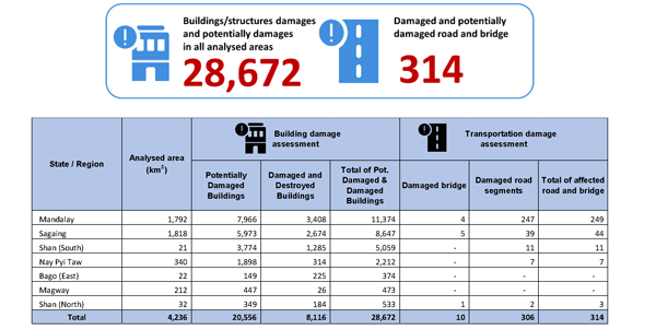
This comprehensive satellite-derived building damage analysis identified a total of 28,672 buildings or structures with visible damage in the assessed areas, including Magway, Mandalay, Sagaing, Bago (East), Nay Pyi Taw, Shan (North), and Shan (South) States. Additionally, approximately 314 locations with damaged or potentially damaged roads and bridges were identified..

📝More details in the report.

The United Nations University Institute for Water, Environment and Health (UNU-INWEH) recently published a report,calling for enforcing resilient building codes and using remote sensing based rapid response systems for saving lives.

Using synthetic aperture radar (SAR) data from the Sentinel-1 satellite, UNU researchers assessed the damage in the hard-hit cities of Mandalay, Pyin Oo Lwin, Madaya, Kyaukse, Sagaing, Shwebo, and Woundwin. Key findings from the report detail the widespread destruction, with over 157,000 buildings identified as likely damaged.

📝More details in the report.


The Myanmar Economic Monitor (MEM), published semiannually by the World Bank’s Myanmar office, has recently released its latest edition. This report covers the impact of the March earthquake, highlighting how the resulting economic aftershocks are compounding ongoing challenges for firms and households.

The MEM projects a 2.5 percent contraction in Myanmar's gross domestic product (GDP) for the 2025/26 fiscal year, primarily due to the earthquake's impact.

Production across all sectors has been disrupted by factory closures, supply chain constraints, labor shortages, and damage to infrastructure. Economic output for the current fiscal year is projected to be approximately US$2 billion lower due to the earthquake. The worst-affected regions, Mandalay and Nay Pyi Taw, are expected to experience about a third reduction in their output between April and September. However, a partial recovery is anticipated in the latter half of the fiscal year, supported by reconstruction efforts.

📝More details in the document.

Explore these 3 maps (data as of 31 March 2025), from UNOCHA.

  1. Kachin and northern Shan states
  2. Shan State
  3. Kachin State

Armed Conflict Location and Event Data (ACLED) released the regional overview for asia-pacific covering the month of May 2025, showing 896 recorded events in Myanmar.
📝 More on the ACLED website.

The River Water Level Dashboard, hosted on the MIMU website, courtesy of Myanmar Geoinformatics Society, provides daily updates on water levels and warning statuses for major rivers, measured at various towns along the riverbanks.

📝Explore the dashboard.

More than two months after the destructive earthquakes hit central Myanmar on 28 March, the conditions remain dire, particularly in displacement sites across Mandalay and Sagaing, the epicentre of the quakes.

The early onset of the monsoon season has further intensified existing vulnerabilities. Poor drainage and inadequate sanitation in overcrowded displacement sites have led to cases of acute watery diarrhoea (AWD) and skin infections, raising concerns about potential cholera, malaria, and dengue outbreaks..

📝Read more in the report.

UNDP has recently published a study, based on a survey conducted in July 2024 with 667 respondents, provides a detailed portrait of the deepening vulnerabilities affecting Yangon’s urban and peri-urban communities in the wake of economic downturn, political instability, displacement, and amid a backdrop of shrinking international aid and donor support that has further constrained response capacity.

The scale of urban poverty has risen dramatically in recent years. In 2017, 10% of Yangon’s urban population was classified as poor. By 2023, this figure had increased to 43%. Given Yangon’s total urban population of approximately 6.2 million people, this translates into an increase of about 2 million, with nearly 2.7 million individuals now living in poverty.

📝Read more in the report.

This UNDP report, titled “Stitches of Struggle and Hope: The Realities of Garment and Apparel Workers in Myanmar”, builds on 2022 study Livelihoods Hanging by a Thread to provide an updated picture of Myanmar’s garment workers, four years after the military takeover. Based on 667 interviews in Yangon and Bago, it captures how living and working conditions have further declined for a predominantly young, female, and migrant workforce. Most workers still earn below subsistence levels—averaging less than USD 100 per month—and regularly work long hours under insecure and often unsafe conditions.

📝Read more in the report.

We are currently updating Assessment/Publication Dashboard and Data and Overview Report, which includes over 2,600 inputs from 199 agencies last year.

Please share your planned, ongoing, or completed assessments with us, following our Assessment and Publication Guidelines. This exercise serves as a resource to better coordinate information gathering initiatives, and to share plans, results, methodologies, data, and expertise.

For assistance, contact our focal person, Ko Zin Min Tun at [email protected] or call 09 7740 777 61 during office hours.