News

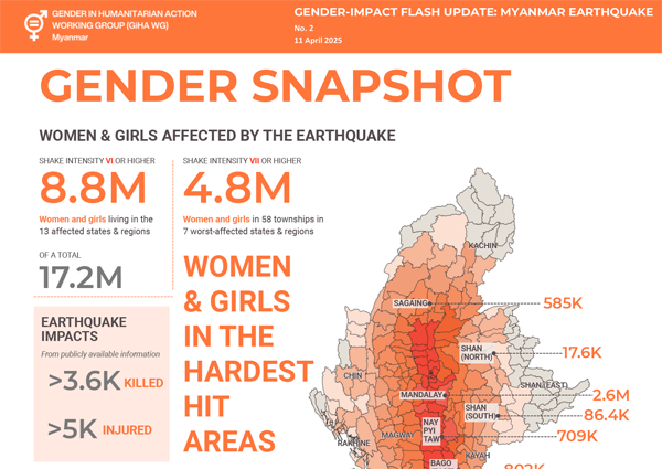
In the aftermath of a major disaster like the recent earthquake, an early recovery approach takes place during a transition period that represents a vital bridge between emergency relief and longer term development and is crucial to the first efforts of the community to recover and build their resilience.

As one of the few partners with extensive field presences and area based programmes, UNDP is well positioned to gather data and provide immediate quick impact localized responses. UNDP’s vast network of civil society partners enable extended reach into remote more rural areas that are also affected. Furthermore, UNDP can coordinate closely with humanitarian actors, including sharing vital data and teaming with on ground presence.

UNDP’s early recovery priorities include:

  • Restarting micro and small enterprises
  • Repairing vital public infrastructure
  • Debris and waste management
  • Technical and Vocational Education and Training (TVET)
  • Renewable Energy Solutions
  • Rapid socio economic analysis and assessments

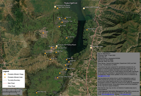
Read more on UNDP’s immediate response and early recovery priorities in this document.

Three weeks after the earthquakes, frequent strong aftershocks continue to shake central Myanmar almost daily, increasing fear and uncertainty among affected families, disrupting response efforts, and further exacerbating pressure on already limited resources and services.

Life saving assistance is being delivered on the ground while technical level assessments are under way to guide a more targeted response. Despite these efforts, the scale and urgency of the emergency exceed current response capacity, with needs rapidly outpacing available resources.

See the full breakdown of impact, affected population + response and planned activities in the latest Situation Report from UNOCHA.

  • Education – In 38 townships across eight regions, at least 103,980 school aged children were affected. Assessments in 43 townships found 818 schools damaged and 279 either destroyed or non functional.
  • Food Security – More than 301,000 people need food assistance in 14 townships of Mandalay Region and four townships of Sagaing Region.
  • Health – 640 health facilities were damaged, particularly in Sagaing Region.
  • Logistics – Additional storage space is required in Mandalay and Sagaing to meet rising demand as more relief cargo arrives. 
  • Nutrition – Immediate interventions are essential to prevent deterioration, including emergency life saving services, feeding programmes, multiple micronutrient supplementation, and support for infant and young child feeding (IYCF).
  • Protection – Overcrowded, inadequate living conditions, coupled with rising anxiety and livelihood loss, heighten risks of exploitation, abuse, and other harmful practices—especially for children, women, older persons, and persons with disabilities.
  • Shelter, NFI, CCCM – People in need of shelter, NFIs, and CCCM support have surged from 1 million to 5.2 million in the affected areas.
  • WASH – Rapid needs assessment findings show extensive damage: over 64,000 latrines destroyed and 37 percent of water facilities damaged. In Sagaing Region, only 27 percent of respondents report access to sufficient latrines and 17 percent have access to safe drinking water, well below WASH Cluster emergency response standards.

In the aftermath of the earthquake, negative coping mechanisms—such as early marriage, child labor, and trafficking—are on the rise, necessitating an immediate scale up of gender responsive protection interventions. Overcrowded shelters with inadequate sanitation and hygiene facilities, and a lack of gender segregated shelters or safe spaces, have significantly increased the risks of gender based violence. Psychosocial distress is widespread and continues to worsen due to the more than 200 aftershocks recorded to date, which have disrupted rescue and relief operations. Frontline responders also face emotional exhaustion and secondary trauma.

Learn more about the response from UNFPA and partners including life saving SRH services, gender based violence prevention, and mental health and psychosocial support, in the latest report.

The Market Analysis Unit has just published detailed results from the Rapid Market Assessment (RMA) conducted after the 28 March earthquake in Myanmar. The report provides township level data on market function, activity, supply, and logistics across three earthquake affected regions. Data were collected through observation and key informant interviews with retailers in 25 markets between 1 and 10 April.
Read more on the report.

The Market Analysis Unit is an independent project that provides donors, humanitarian responders, development practitioners and private sector actors in Myanmar with data and analysis to better understand the impacts of market developments, conflict and other crises on household purchasing power, supply chains, financial services, and labour markets.

In yesterday’s updates, we highlighted the earthquake damage to hundreds of religious buildings, heritage and cultural sites, with the earthquake’s epicenter near historic cities Sagaing and Mandalay.

Since then, the United Nations Satellite Centre (UNOSAT) has released 4 more maps to assess probable damage at many of those sites in Myanmar using very high resolution satellite imagery.

The summary below combines those from yesterday with today’s four new maps:

  • Min Kun – 11 damaged / 3 possibly damaged
  • Pinya – 6 damaged / 5 possibly damaged
  • Mahamuni Pagoda – 30 damaged within the area
  • Tada-U – 34 damaged buildings within the cultural site were observed and an additional 7 buildings have possible damage
  • Innwa (Ancient Cities of Upper Myanmar) – 18 damaged / 2 possibly damaged buildings inside the site, 25 damaged / 5 possibly damaged in its buffer zone, plus damaged southern wall.
  • Mandalay Palace & city walls – 17 damaged / 9 possibly damaged structures and multiple damages in the moat wall.
  • Amarapura – 8 damaged within the cultural site including two towers (inset 1), the Shwe Lin Pin Pagoda (inset 2) and another pagoda on the south-eastern wall.
  • Sagaing – 760 damaged buildings within the cultural site, including several pagodas such as Ma Shi Khana Pagoda. No damage detected on the Sitagu International Buddhist Academy.
  • Mingun – 4 damaged buildings within the cultural site, including the Hsinbyume Pagoda, Mingun Pahtodawgyi and Sat Taw Yar Pagoda.
  • Bagan World Heritage Site (Component 7) – no visible damage
  • Shwe Kyaung Monastery (Konbaung period wooden monastery) – no visible damage
  • Sri Ksetra (Pyu Ancient Cities) – no visible damage

Please Note: This is a preliminary analysis based on satellite imagery and has not yet been validated in the field. UNOSAT welcomes ground feedback to refine the assessment.

Download the maps on MIMU website.

NASA JPL teams used radar and optical images from ESA’s Sentinel 1 and Sentinel 2 satellites into a map of how the land displaced during the 28 March Mw 7.7 earthquake and its Mw 6.7 aftershock. Pixels west of the Sagaing Fault slid north (red); pixels to the east slid south (blue), exposing over 3 metres of motion on each side—more than 6 metres of total offset in some places.

Read more in the article.


In the aftermath of the earthquake, Nyaungshwe Township in Southern Shan—especially the Inle Lake area—has suffered some of the region’s most extensive damage, with entire floating villages reportedly submerged.
We have developed a probable damage map based on social media reports of affected villages and hotels (Inle Lake is a major tourism hub with many hotels). We are now working with partners to validate and improve this map using satellite imagery and field reports.

Download the map from MIMU website.

With more than 10 million women and girls already in humanitarian need before the earthquake, the disaster has further intensified their risks—cutting off access to essential health and protection services and exposing them to unsafe shelter, heightened risk of violence, and barriers to safe, private sanitation and hygiene facilities.

4.8 million women and girls live in 58 townships across the seven worst affected states and regions.

Read more in the Gender Impact Flash Update: Myanmar Earthquake No. 2.

With the earthquake’s epicenter near historic cities Sagaing and Mandalay, hundreds of religious buildings, heritage and cultural sites were destroyed, threatening the preservation of cultural heritage and community wellbeing.

The latest maps from the United Nations Satellite Centre (UNOSAT) assess probable damage at many UNESCO World Heritage and Tentative List sites using very high resolution satellite imagery.

  • Innwa (Ancient Cities of Upper Myanmar) – 18 damaged / 2 possibly damaged buildings inside the site, 25 damaged / 5 possibly damaged in its buffer zone, plus damaged southern wall.
  • Mandalay Palace & city walls – 17 damaged / 9 possibly damaged structures and multiple damages in the moat wall.
  • Amarapura – 8 damaged within the cultural site including two towers (inset 1), the Shwe Lin Pin Pagoda (inset 2) and another pagoda on the south-eastern wall.
  • Sagaing – 760 damaged buildings within the cultural site, including several pagodas such as Ma Shi Khana Pagoda. No damage detected on the Sitagu International Buddhist Academy.
  • Mingun – 4 damaged buildings within the cultural site, including the Hsinbyume Pagoda, Mingun Pahtodawgyi and Sat Taw Yar Pagoda.
  • Bagan World Heritage Site (Component 7) – no visible damage
  • Shwe Kyaung Monastery (Konbaung period wooden monastery) – no visible damage
  • Sri Ksetra (Pyu Ancient Cities) – no visible damage

Please Note: This is a preliminary analysis based on satellite imagery and has not yet been validated in the field. UNOSAT welcomes ground feedback to refine the assessment.

Download the maps on MIMU website.

Township-level sectoral maps based on data from the latest February 2025 round of the HDP Nexus 5W are now available on MIMU website. These maps provide a very recent snapshot of humanitarian, development, and peace activities on the ground before the earthquake, providing a pre-disaster baseline. Due to their sector-specific focus, these maps are especially helpful for response and recovery operations. For example, the WASH sector map can support planning and coordination for water and sanitation needs in affected areas.