News

NASA JPL teams used radar and optical images from ESA’s Sentinel 1 and Sentinel 2 satellites into a map of how the land displaced during the 28 March Mw 7.7 earthquake and its Mw 6.7 aftershock. Pixels west of the Sagaing Fault slid north (red); pixels to the east slid south (blue), exposing over 3 metres of motion on each side—more than 6 metres of total offset in some places.

Read more in the article.


In the aftermath of the earthquake, Nyaungshwe Township in Southern Shan—especially the Inle Lake area—has suffered some of the region’s most extensive damage, with entire floating villages reportedly submerged.
We have developed a probable damage map based on social media reports of affected villages and hotels (Inle Lake is a major tourism hub with many hotels). We are now working with partners to validate and improve this map using satellite imagery and field reports.

Download the map from MIMU website.

With more than 10 million women and girls already in humanitarian need before the earthquake, the disaster has further intensified their risks—cutting off access to essential health and protection services and exposing them to unsafe shelter, heightened risk of violence, and barriers to safe, private sanitation and hygiene facilities.

4.8 million women and girls live in 58 townships across the seven worst affected states and regions.

Read more in the Gender Impact Flash Update: Myanmar Earthquake No. 2.

With the earthquake’s epicenter near historic cities Sagaing and Mandalay, hundreds of religious buildings, heritage and cultural sites were destroyed, threatening the preservation of cultural heritage and community wellbeing.

The latest maps from the United Nations Satellite Centre (UNOSAT) assess probable damage at many UNESCO World Heritage and Tentative List sites using very high resolution satellite imagery.

  • Innwa (Ancient Cities of Upper Myanmar) – 18 damaged / 2 possibly damaged buildings inside the site, 25 damaged / 5 possibly damaged in its buffer zone, plus damaged southern wall.
  • Mandalay Palace & city walls – 17 damaged / 9 possibly damaged structures and multiple damages in the moat wall.
  • Amarapura – 8 damaged within the cultural site including two towers (inset 1), the Shwe Lin Pin Pagoda (inset 2) and another pagoda on the south-eastern wall.
  • Sagaing – 760 damaged buildings within the cultural site, including several pagodas such as Ma Shi Khana Pagoda. No damage detected on the Sitagu International Buddhist Academy.
  • Mingun – 4 damaged buildings within the cultural site, including the Hsinbyume Pagoda, Mingun Pahtodawgyi and Sat Taw Yar Pagoda.
  • Bagan World Heritage Site (Component 7) – no visible damage
  • Shwe Kyaung Monastery (Konbaung period wooden monastery) – no visible damage
  • Sri Ksetra (Pyu Ancient Cities) – no visible damage

Please Note: This is a preliminary analysis based on satellite imagery and has not yet been validated in the field. UNOSAT welcomes ground feedback to refine the assessment.

Download the maps on MIMU website.

Township-level sectoral maps based on data from the latest February 2025 round of the HDP Nexus 5W are now available on MIMU website. These maps provide a very recent snapshot of humanitarian, development, and peace activities on the ground before the earthquake, providing a pre-disaster baseline. Due to their sector-specific focus, these maps are especially helpful for response and recovery operations. For example, the WASH sector map can support planning and coordination for water and sanitation needs in affected areas.


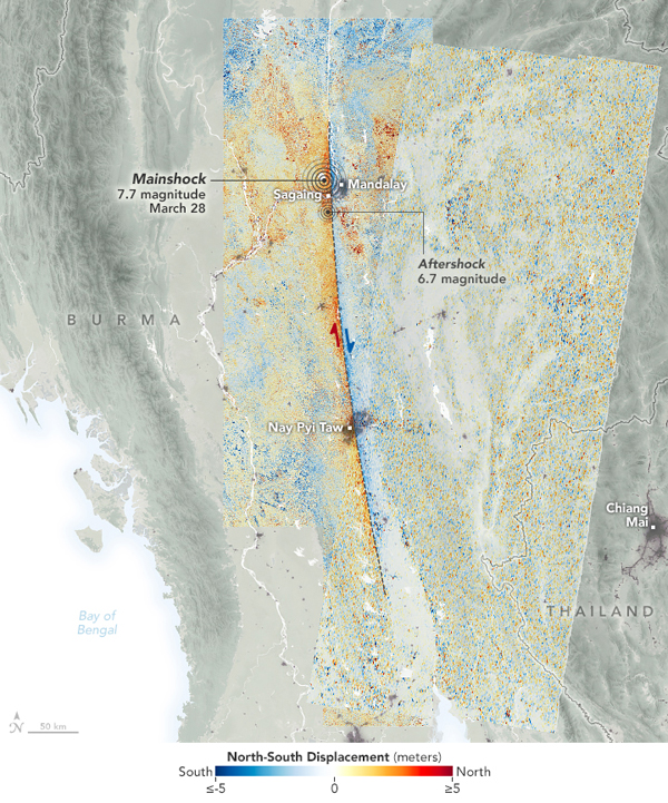
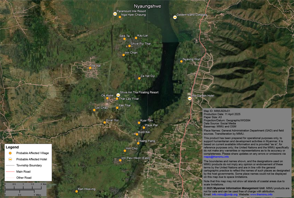
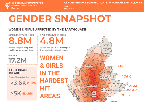
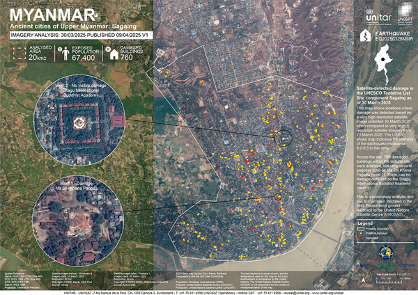
As you are aware, we have been compiling all reports, maps, publications, and related materials on the 2025 earthquake.

As part of our longstanding Assessment Tracking Exercise, we’d like to request your inputs on any completed, ongoing, or planned assessments and surveys related to the earthquake. Just like in the regular exercise, this emergency request aims to support coordination and avoid duplicative assessments, which can strain limited resources and burden affected communities.

We will reach out to assessment focal points in the coming days. In the meantime, please share your information through the offline Excel form, or if you are already a MIMU contributor, use the online web form along with the provided guideline.

We understand the sensitivities around certain assessments. As with the regular tracking exercise, non-public reports will not be published on the MIMU website. Only anonymized and aggregated data (e.g., number of assessments in a particular township) will be recorded.

The latest Article from Center for Development and Environment (CDE), University of Bern, features the use of OSM for Humanitarian and Development Activities. Dubbed as the “Wikipedia of Cartography.””, OSM is a collaborative, open-source mapping project that provides free, editable geographic data to users worldwide.

In Myanmar, where there are many limitations on ground mapping, particularly in hard-to-reach areas during disasters and conflict, OSM plays a crucial role in quickly generating accurate, community-driven maps to support emergency response and planning.

In response to the earthquake, the Humanitarian OpenStreetMap Team (HOT), together with the global open mapping community, is supporting Myanmar's OpenStreetMap community (myOSM) to improve the quality of building footprint and road data in affected towns and communities. Through this newsletter, we’ve been sharing the calls to contribute on the mapping platform.

Read more on the MIMU website.


The latest map from the United Nations Satellite Centre (UNOSAT) shows the density of damaged buildings caused by the March 28, 2025 earthquake, focusing on Mandalay and Sagaing Districts.

  • Within the map extent of about 2,100 km², UNOSAT, Copernicus EMS and ICube-SERTIT observed a total of 4,764 destroyed and damaged structures & 4,369 potentially damaged structures.
  • Within Mandalay City boundary of about 110km², a total of 1,076 structures are observed as destroyed and damaged, & a total of 519 structures are observed as potentially damaged.

Please Note: This is a preliminary analysis based on satellite imagery and has not yet been validated in the field. UNOSAT welcomes ground feedback to refine the assessment.

Data from the United States Geological Survey (USGS) shows that, in the past 24 hours, Myanmar experienced three smaller aftershocks with epicenters located in Mandalay and Sagaing Regions:

  • M 4.7 – 32 km NE of Shwebo at 2:28 PM, 9 Apr 2025
  • M 3.6 – 27 km SW of Kyaukse at 9:10 PM, 9 Apr 2025
  • M 3.5 – 14 km NW of Kyaukse at 10:29 PM, 9 Apr 2025

We are monitoring latest earthquakes from both USGS and Thai Meteorological Department (TMD) and recording them in an interactive map.

The latest dashboard from MIMU aims to provide detailed insights into the humanitarian impact and to support response efforts following the earthquake. This interactive dashboard features:

  • Township-level maps highlighting earthquake intensity, population distribution, and existing activities based on HDP Nexus 5W data. It also features 58 most-affected townships.
  • Key figures, including the number of destroyed and damaged buildings based on satellite imagery.
  • Presence and sectoral distribution of agencies active prior to the earthquake, based on HDP Nexus 5W data.